INSHORE REEFS
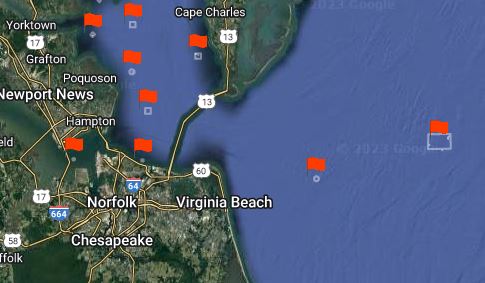
The inshore artificial reefs in the lower Chesapeake Bay are man-made structures, that are easy for anglers to get to. They provide habitat for various marine species, they are designed to mimic natural reefs and enhance the biodiversity and productivity of the bay. There are a number of artificial reefs that have been created over the years using various materials such as concrete, steel, and wood. Here are just a few.
– The Chesapeake Bay Bridge-Tunnel (CBBT): The big one! This remarkable engineering feat that connects two regions of Virginia across the mouth of the bay. It also serves as an artificial reef, attracting a variety of fish and other marine life. The CBBT is 17.6 miles long and consists of bridges, tunnels, causeways, and artificial islands. It is the largest artificial reef structure in the Chesapeake Bay region and provides a unique habitat for many species.
– The Cabbage Patch Reef: An artificial reef located off the coast of Cape Charles. It was established in 2000. The reef consists of various materials, such as concrete rubble, bridge pilings, barges, and vessels. Some of the materials came from the demolished Lesner Bridge in 2017. The reef covers an area of about 80 acres and provides habitat for many fish species, such as black sea bass, tautog, flounder, croaker, spot, and striped bass. Cabbage Patch Reef is one of the most productive fishing grounds in the Bay and attracts anglers from all over the region.
– East Ocean View Reef: This is an artificial reef located about 900 yards off Oceanview beach and marked by a yellow buoy, its about 27 feet deep. It was created by deploying concrete structures and bridge rubble on the seabed, providing habitat for various marine species.
– Bluefish Rock Reef: This reef is about 4.5 nautical miles east of Buckroe Beach and Saltponds. The reef was constructed in 2007 with concrete pipe and other materials. It attracts various fish species and offers opportunities for snorkeling and scuba diving.
– Mobjack Bay Reef: An artificial reef located about 2.75 miles southwest of New Point Comfort and covers an area of about 80 acres . The reef consists of various materials, such as concrete pipe, bridge sections, pile caps, and demolition materials . These materials provide habitat and structure for various fish species, such as striped bass, speckled trout, redfish, croaker, and spot . The reef also attracts baitfish and crabs, which in turn attract more predators. The reef is a popular destination for anglers who enjoy light-tackle casting or trolling with floating plugs . The reef offers a sheltered spot during windy conditions and is accessible by boat from several nearby ramps.
– York Spit Reef: An artificial reef located east of the entrance to the York River, near the New Point Comfort Shoal. It was created using concrete pipes, reef balls, and bridge sections donated by various companies. The reef covers a square area of about 0.5 nautical miles and has a depth of 30 feet and a profile of 4 to 10 feet. The reef is well situated in a productive fishing area and is accessible from the Middle Neck and upper Tidewater areas. It offers a variety of vertical reef structures to explore and attracts many fish species, such as flounder, croaker, spot, sea bass, tautog, and cobia.
– Cherrystone Reef: This reef is located 1.8 nautical miles NNW of Cherrystone Creek, bayside of the Eastern Shore. It consist of concrete igloos, stacks of concrete pipe, concrete deck sections from the Chesapeake Bay Bridge Tunnel, and over 2900 Tires In Concrete (TICs) have been scattered on this site. In 2006, 2000 tons of concrete block were added.
– Back River Reef: This is a circular artificial reef site located 3 nautical miles east of Plumtree Point, between Back River and the Poquoson River. It has a depth of 24 feet and a profile of 3-8 feet. It consists of various materials such as concrete igloos, tetrahedrons, pipe, bridge sections, and piles. It is a popular fishing destination for species such as striped bass.
– The Cell Reef: This is a coral formation that lies west of Hungars Creek, a tidal inlet on the Eastern Shore of Virginia. One thousand tons of concrete pipe was added to this site in 2001. In 2006, 2000 tons of concrete block was added. The reef is home to a variety of marine life, including fish, crabs, and sea turtles.
– Occohannock Reef: This is a man-made oyster reef located in the Chesapeake Bay. It was constructed in 1994. The reef covers an area of about 32 acres and provides habitat for oysters and other marine life. The reef consists of different types of materials, such as concrete tetrahedrons, reef balls, rock, and sunken vessels. The reef attracts a variety of fish species, such as black sea bass, tautog, flounder, and croaker.
Fishing around inshore artificial reefs can be rewarding, but also challenging. Here are some tips on how to fish around them:
– Use a fish finder or a depth finder to locate the reefs and identify the depth and structure of the bottom.
– Choose the right type of anchor. Choose the right tackle and bait for the target species. Some common fish that can be found around artificial reefs are striped bass, flounder, black sea bass, tautog, and bluefish. You can use live or cut bait, such as minnows, squid, crabs, or clams, or artificial lures, such as jigs, spoons, or plugs.
– Fish near the edges or gaps of the reefs, where fish tend to congregate and feed. Avoid snagging your line on the reef by using a sinker that is heavy enough to keep your bait near the bottom, but not too heavy that it gets stuck in the structure.
– Be respectful of other anglers and boaters who may be fishing or navigating around the same reef. Keep a safe distance and follow the local regulations and etiquette.
– Practice catch and release if you are not planning to keep your fish. Use circle hooks and barbless hooks to minimize injury and mortality of the fish. Handle the fish gently and release them as quickly as possible.
OFFSHORE REEFS
– Tower Reef: This is an artificial reef site that lies 0.6 nautical miles west-southwest of the Chesapeake Light Tower off the coast of Virginia. It was established in 1970 and contains various structures such as barges, vessels, subway cars and drydock sections. The reef attracts many species of fish and provides a habitat for mussels and other marine life. The depth of the reef ranges from 42 to 60 feet and the profile varies from 2.5 to 24.5 feet .
– The Triangle Reef is a popular offshore, deep ocean, fishing spot off the coast of Virginia Beach, where several sunken ships lie on the ocean floor. The Triangle Wrecks are located about 30 nautical miles east of Rudee Inlet and 16.5 nautical miles from Chesapeake Light Tower. The water depth is around 90 to 100 feet and the wrecks have a profile relief of 28 to 32 feet. You can use jigs, bottom rigs, or plugs to fish these wrecks, depending on what species you are targeting. The wreck site attracts a variety of fish species, such as black sea bass, tautog, flounder, spadefish, triggerfish, king mackerel and amberjack. Fishing the Triangle Wreck can be a rewarding and exciting experience, but it also requires some preparation and safety precautions. This is a long run offshore, and it is highly recommended you have an experienced person onboard if its your first deep-sea trip.
Here are some tips on how to fish the Tower and Triangle Wrecks off Virginia Beach:
– Check the weather and sea conditions before you go. The Tower and Triangle Wreck are offshore, so you need a boat that can hold lots of fuel and handle the open water. You also need to make sure the wind, waves, and currents are favorable for fishing and navigation. Avoid going when there is a small craft advisory.
– Use a GPS or a chart to locate the wreck site. The Triangle Wreck is marked by three buoys that correspond to each ship (if weather hasn’t dislodged). You can use a GPS device or a nautical chart to find the coordinates of the buoys and navigate to the wreck site. You can also use a fish finder or a depth sounder to locate the wrecks on the bottom.
– Anchor your boat near the wreck site. Once you find the wreck site, you need to anchor your boat securely and safely. You can either anchor directly over the wreck or up-current from it, depending on the direction of the current and the wind. Make sure your anchor line is long enough to reach the bottom and has enough slack to account for the tide and the waves. You also need to make sure your anchor does not snag on the wreck or damage it.
– Use appropriate tackle and bait for the fish you want to catch. The Triangle Wreck offers a variety of fishing opportunities, so you need to use the right tackle and bait for the fish you are targeting. For example, if you want to catch black sea bass or tautog, you can use a bottom rig with a sinker and two hooks baited with squid, clam, or crab. If you want to catch flounder, you can use a jig head with a soft plastic lure or a live minnow. If you want to catch spadefish or triggerfish, you can use a small hook with a piece of clam or shrimp suspended under a float. If you want to catch amberjack, you can use a heavy spinning rod with a large metal jig or a live baitfish.
– Follow the regulations and etiquette for fishing the wreck site. The Tower and Triangle reefs are popular fishing spots, so you need to respect the regulations and etiquette for fishing there. You need to have a valid saltwater fishing license and follow the size and creel limits for each fish species. You also need to respect other anglers and boaters who are fishing or diving at the wreck site. Do not crowd or interfere with other boats or lines, and do not cut or remove any part of the wrecks.
GPS coordinates for each reef can be obtained on the VMRC website.
https://webapps.mrc.virginia.gov/public/maps/artificial_reefs.php


 Views Last 7 days : 1730
 Views Last 30 days : 12939